Access
Access ensures we can continue to reach shorelines and low-lying areas for enjoyment. It also ensures uninterrupted services and emergency access during flood-events.
Round two engagement is now complete. Thank you to everyone who completed the survey or attended the public meeting. A final report will be available by late summer/early fall, with more communications to come.
The City of Nanaimo has over 30 km of coastline along its shores with much of it developed into residential communities, commercial hubs, and corridors for essential services like transportation and utilities. The areas that remain undeveloped have diverse and sensitive ecosystems as well as prized scenic landscapes and views. These coastal areas hold great significance to many Nanaimo residents, providing endless community and environmental benefits. As climate change causes sea levels to rise, we will need to develop resilient strategies to protect what's important to us along Nanaimo's coast.
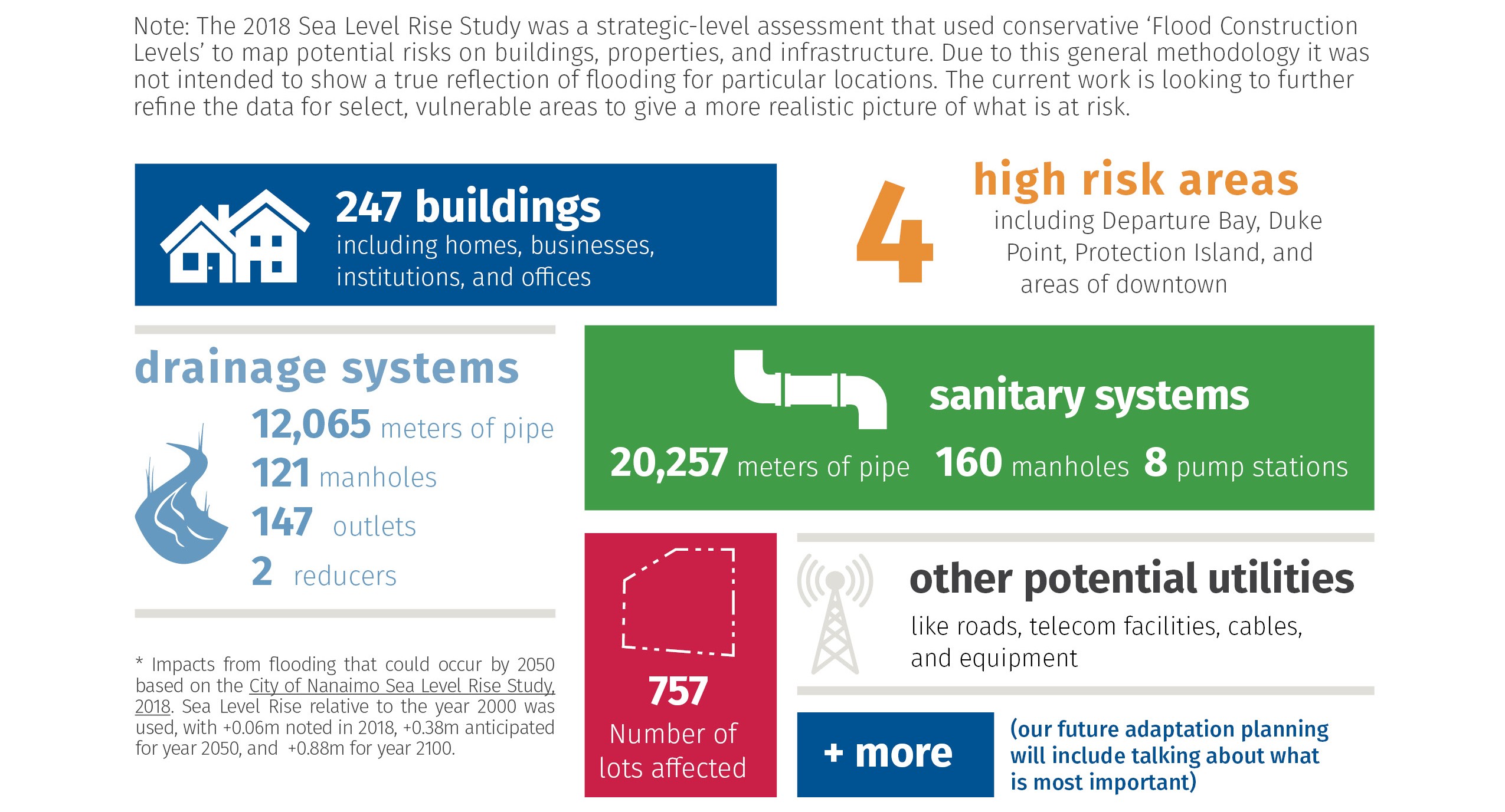
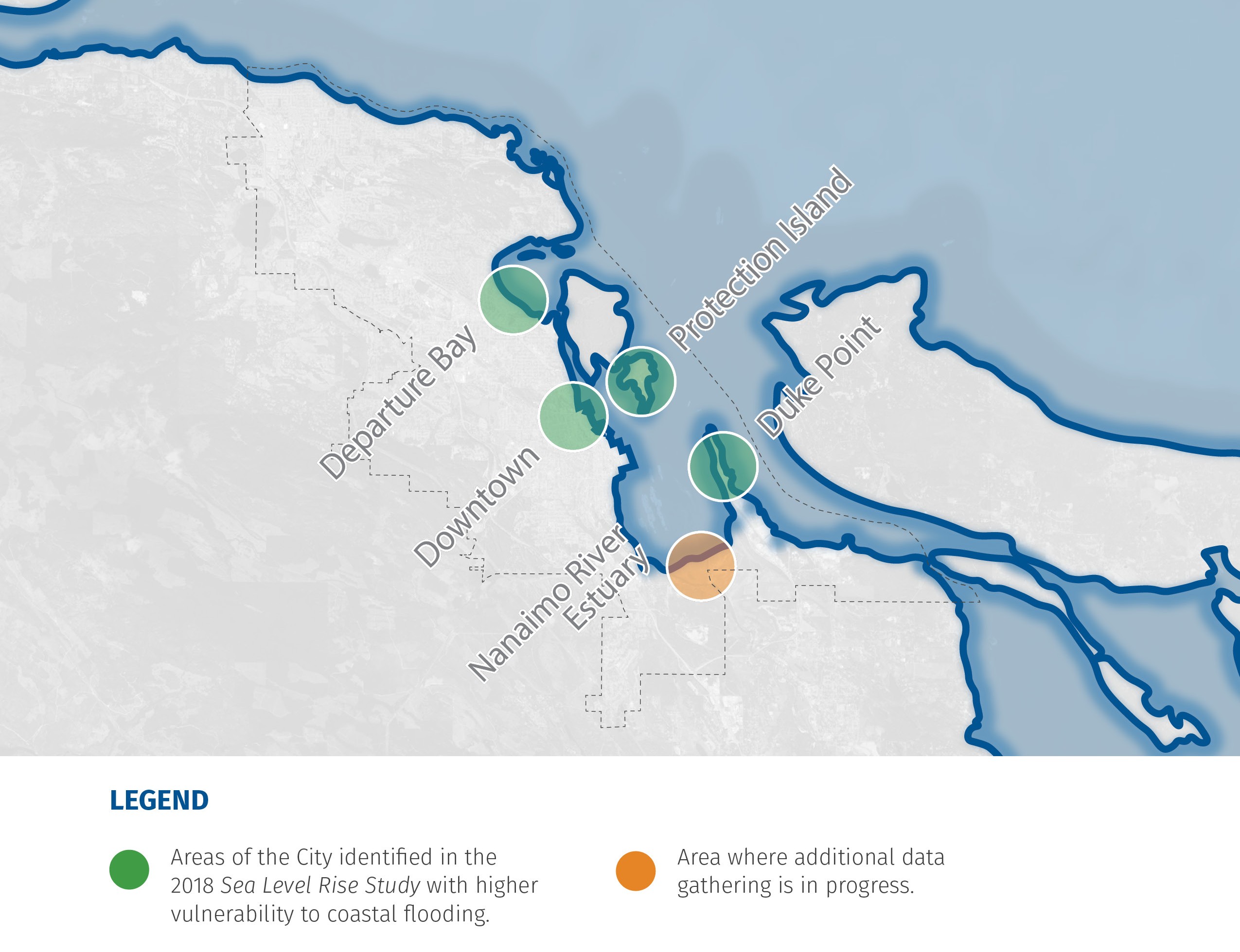
The City of Nanaimo, working with Snuneymuxw First Nation, is developing a Sea Level Rise (SLR) Management Plan to guide coastal adaptation solutions for areas of Nanaimo at risk of coastal flooding. This project builds upon the Sea Level Rise Study completed in 2018, which identified the study areas that are the focus of this project. The graphic below shows what features, based on the 2018 study, could potentially be impacted as sea levels rise by 2050*.
Our Coastal City is being done in coordination with the Regional District of Nanaimo's (RDN) Our Changing Coast project. If you are interested in regional sea level rise impacts and solutions beyond the City's boundaries, check out the RDN Our Changing Coast page on Get Involved RDN. A separate but related project for Nanaimo was necessary due to differing methodology from earlier studies and the need for more Nanaimo-specific information.
Our Coastal City will consist of two phases that will include technical studies as well as engagement with key interest groups and the public. You can learn more by clicking each phase below. To find out more about how you can provide input on this project, please click the How Can I Get Involved tab!
Phase One of the Sea Level Rise Management Plan will improve our understanding of coastal risk through a number of technical studies. The technical information along with community and interest holder engagement will aid in the identification of the preferred sea level rise management options.
Phase One will be in process from SEPT-2025 until JUL-2026
Phase Two of the plan will focus on the development of sea level rise management options and develop a method of communicating the strategy to the public.
Phase Two will be in process from FEB-2026 to SEPT-2026
This project will focus on low lying areas that are most at-risk of impacts of sea level rise:
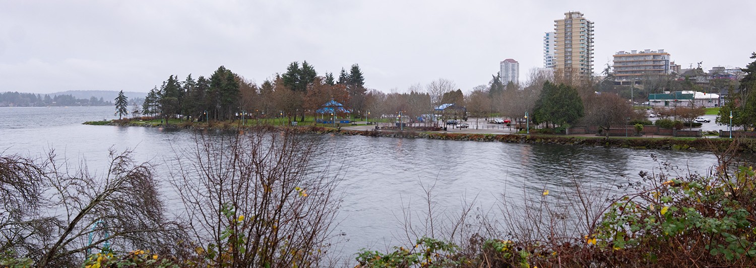
King tide at Maffeo Sutton Park
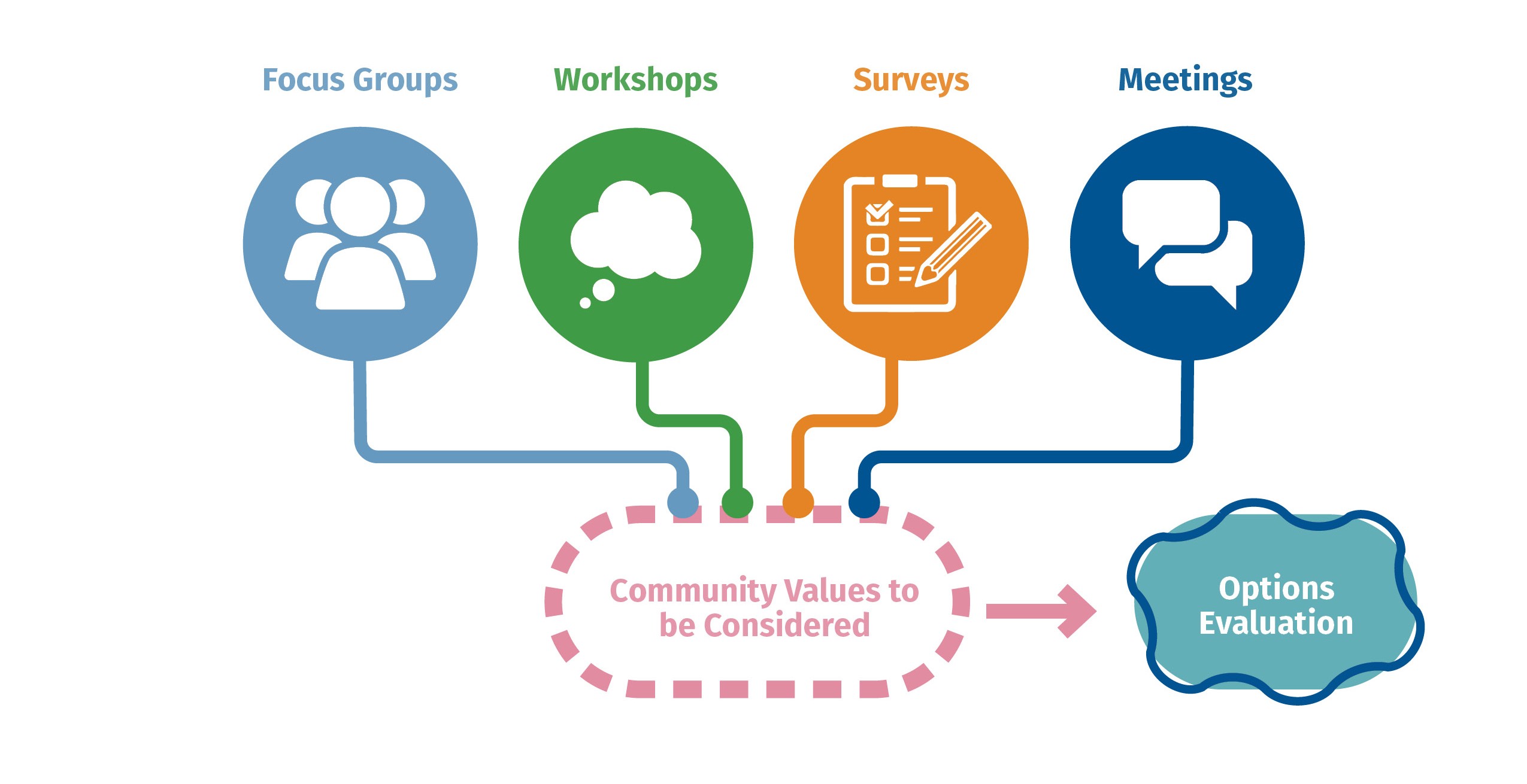
The technical studies will help us to understand what sea level rise problems and risks we will be facing in the future, but an important part of deciding how we tackle these problems is to identify what we value as a community. Those values will be discovered through focus groups, workshops, a survey, and meetings. We need to understand what our collective priorities are in order to map out the journey that we will take to get to our end goal.
Once there is an understanding of community values, we will take those along with the technical studies to create options for adapting to the risks of sea level rise. These options will not just be a single solution, they will be a combination of actions that we can take over time to stay ahead of increasing risks.
The Sea Level Rise Values Survey is now closed. Thank you to everyone who participated! Please click the button below to review the Round One Engagement Summary.
There are many types of values a community might hold related to coastal areas. Below are a few examples of values that might guide our coastal adaptation journey:
Access ensures we can continue to reach shorelines and low-lying areas for enjoyment. It also ensures uninterrupted services and emergency access during flood-events.
Equity & Culture historically centers on marginalized communities, ensuring their needs and cultural priorities are considered.
Economics involves protecting livelihoods, areas of investment and critical assets for long-term financial health.
Recreation needs to guide adaptation so that people can safely enjoy nature and community life as conditions change.
Ecology shapes coastal adaptation by prioritizing the protection and restoration of habitats that buffer storms, support biodiversity and provide co-benefits for people.
Infrastructure focuses on focuses on upgrading, relocating or reimagining built systems so they remain safe, reliable and flexible in the face of rising seas.
An Options Survey is now closed. An updated engagement summary and final report will be shared late summer/early fall 2026.
Options can include physical or policy changes that may need to take place along our shorelines in response to rising sea levels. These options can be broken down into four high level categories: Avoid, Retreat, Protect, and Accomodate.
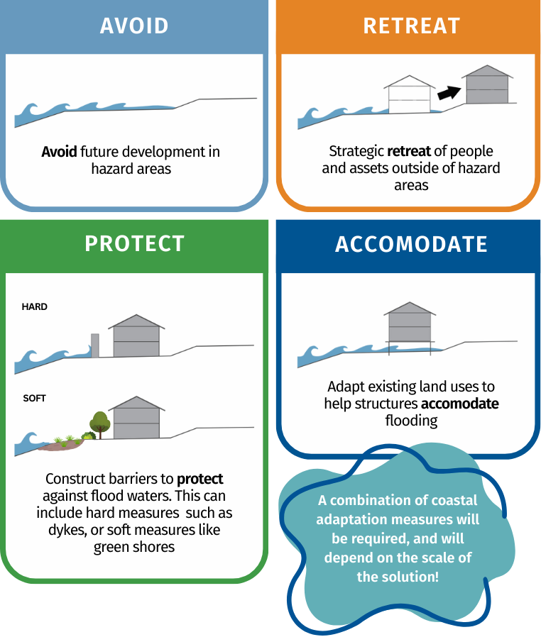
The options presented will include adaptation actions that prepare for sea level rise by laying the groundwork for good decision making that supports future choices that are equitable, inclusive and informed by science, local knowledge and community values. This can include:
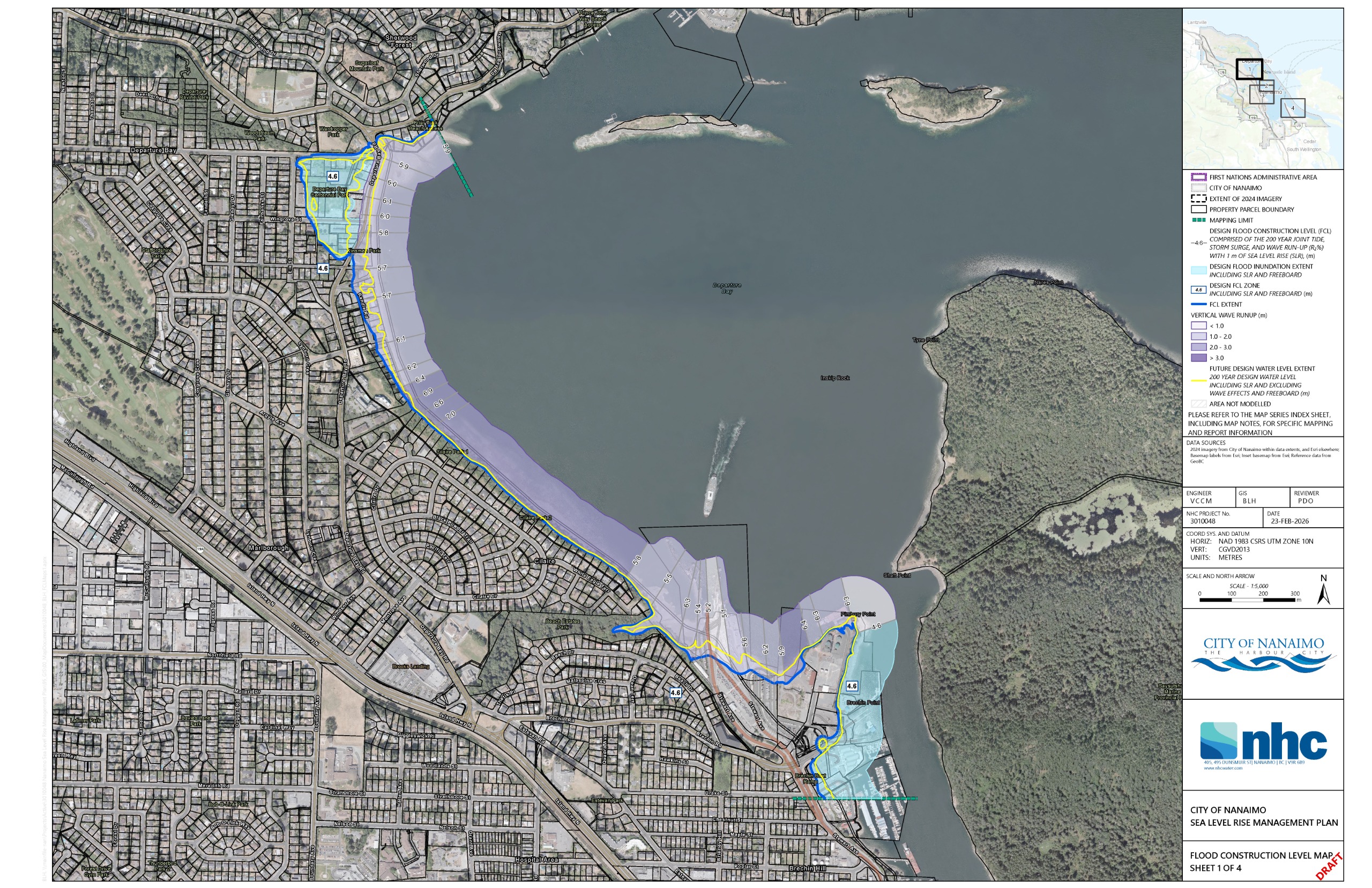
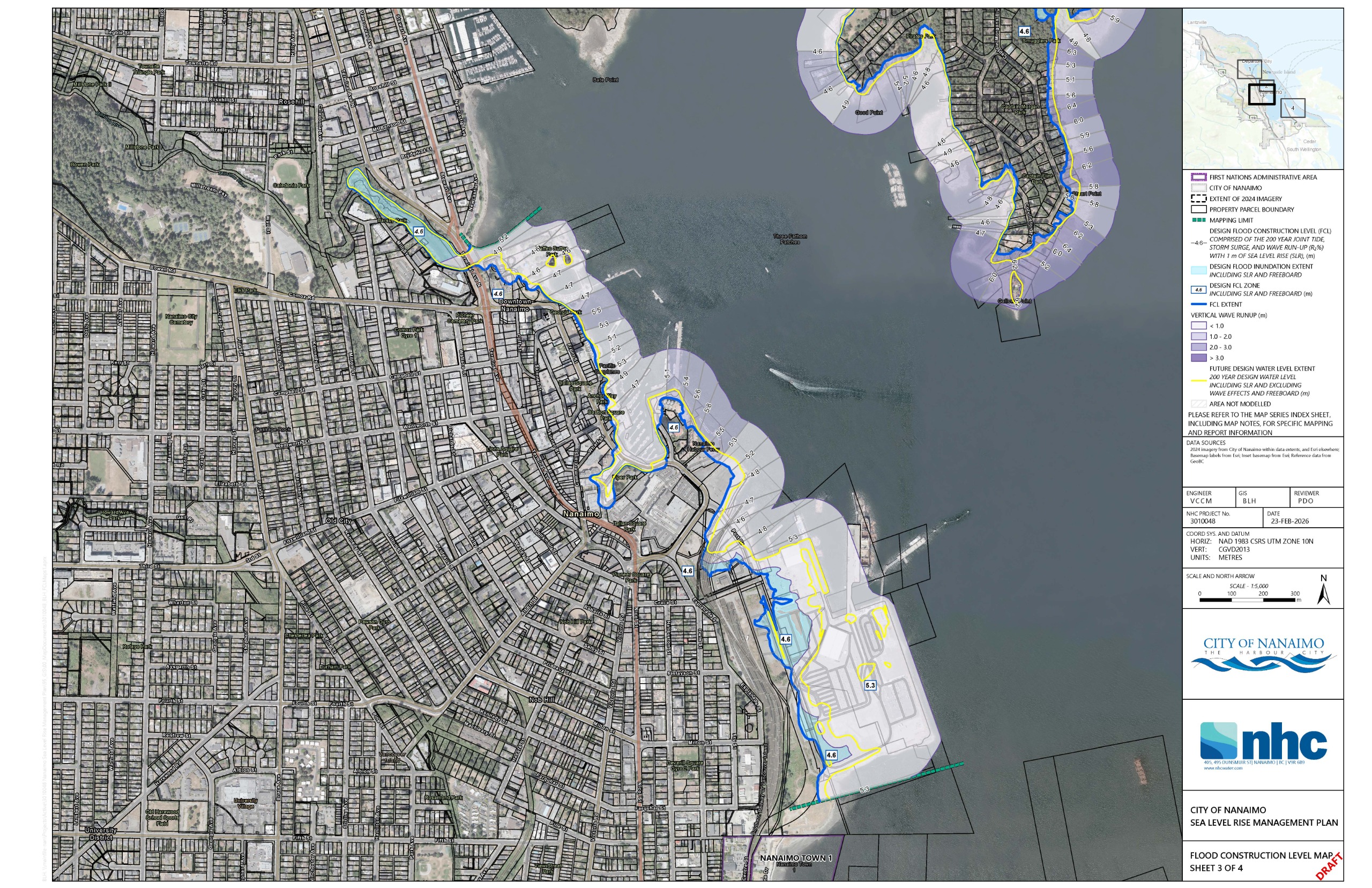
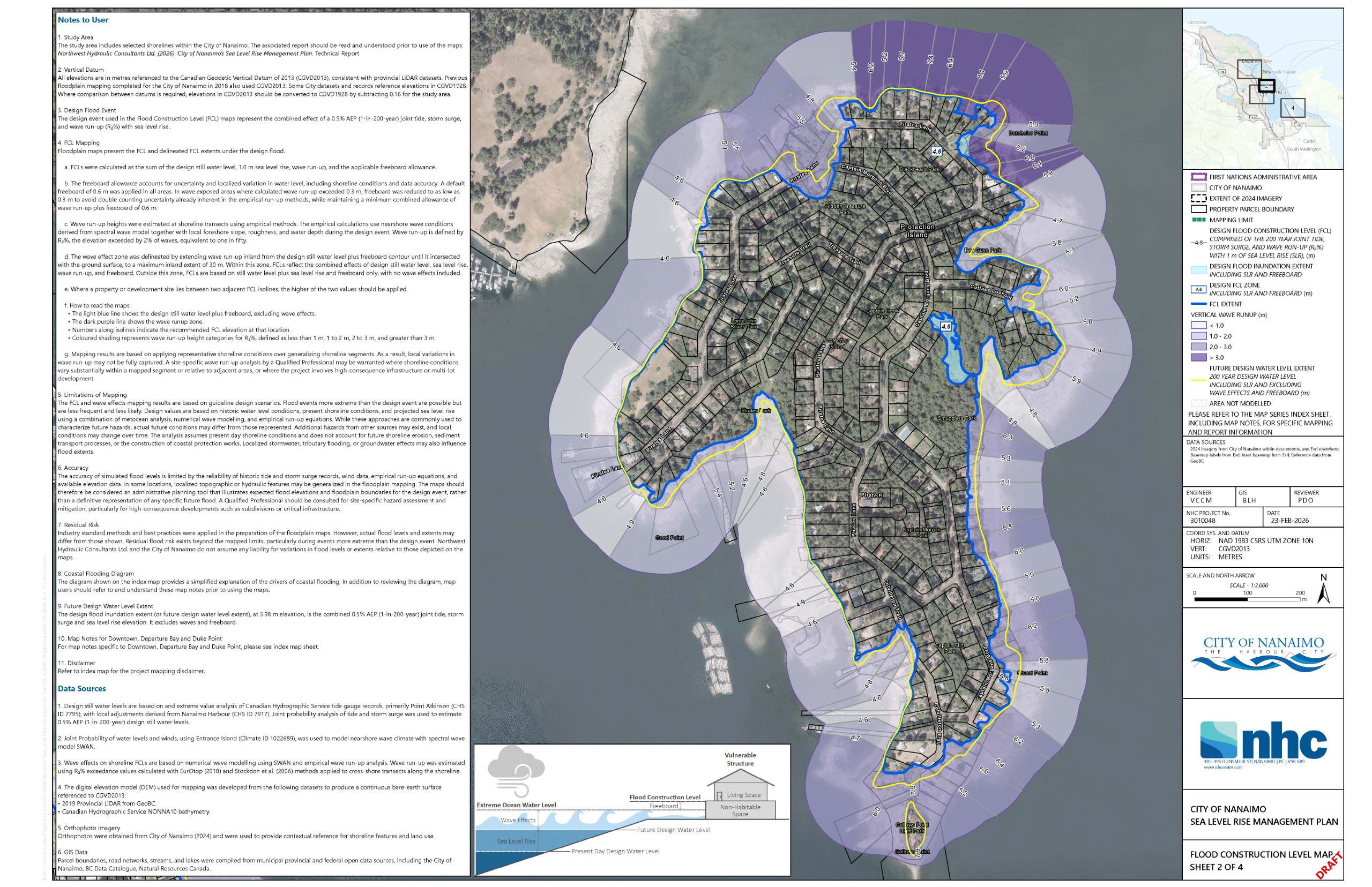
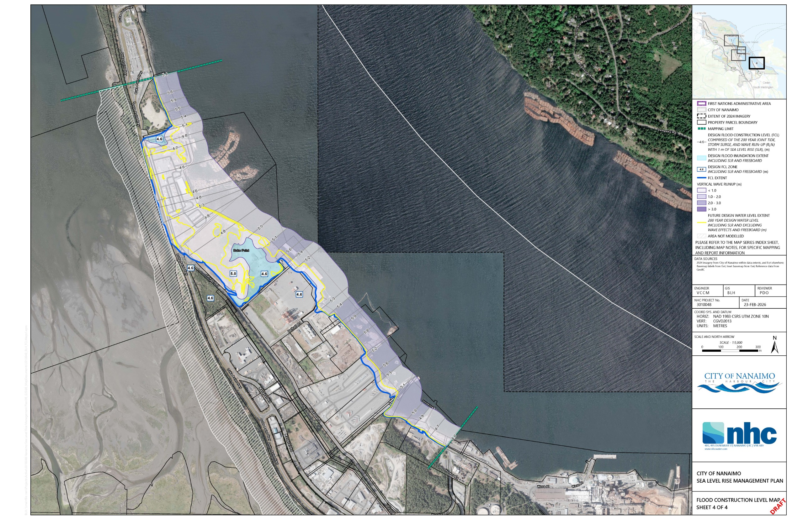
The Nanaimo Floodplain maps show the areas that could be flooded during a future large coastal event that has about a 1 in 200 chance of occurring in any given year. The maps are used to set flood construction levels, or FCLs. An FCL is the minimum elevation required for buildings and infrastructure so that living spaces are protected from flood damage.
The coastal event includes a combination of tides, storm surge, sea level rise, wave effects, and freeboard — a concept that accounts for uncertainty. The design water level is the 1 in 200 year combined tide and storm surge event, with 1 m added to account for future sea level rise. The wave effects are the wave runup caused by the local wave conditions. The resulting water levels are used to set the FCLs. The figure below shows the combination of factors used to set FCLs.
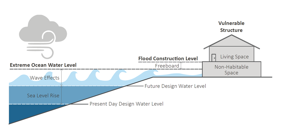
Graphic showing how Flood Construction Levels are calculated.
On the maps, the FCLs are shown as dark grey lines along the shore. The purple areas show where waves could push the water higher than the design water level during a storm (wave runup). Waves can temporarily raise water levels as they break and run up the shore. They can also cause erosion and carry debris such as logs. The wave-affected area extends inland to where waves would reach higher ground, or up to 30 metres inland from the shoreline, whichever is less.
In some locations, flooding may extend beyond the wave-affected area. These areas are shown in blue. In these zones, the FCL is based on the design water level, including sea level rise and freeboard, but without adding extra height for wave effects.
Have questions or want to learn more about a project, contact us below:
| Website | www.nanaimo.ca |
|---|